Last updated: 2026-07-23
11 — Three-dimensional traffic and who builds the sky’s “roads”
The geometry lesson that makes drones different from cars
❓ Why do roads jam while the sky is sold as an escape from congestion?
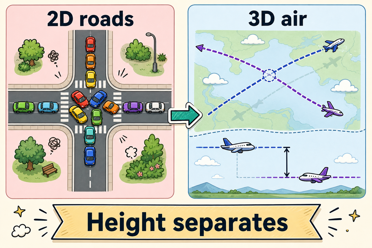
On a map, two car paths are line segments in a plane. Unless they are parallel, extended lines intersect. Cities force those intersections into shared pavement, signals, and stop-and-go. That is not a moral failure of drivers. It is dimension.
Two lines in a plane that are not parallel must meet.
Air mobility marketing often implies: put the trip in the air and the jam disappears. The useful half of that slogan is geometric. Aircraft paths are curves in three-dimensional space. Two trajectories can cross in map view (same lat/lon) while missing in altitude—or miss laterally at the same height—if separation rules hold. You are not forced into a single shared plane of asphalt.
The dangerous half of the slogan is operational. 3D does not delete conflicts; it relocates them.
Conflicts still appear as:
- Same volume at the same time (true 3D collision geometry)
- Takeoff and landing funnels that collapse freedom back toward 2.5D choke points (vertiports, hospital pads, delivery docks)
- Corridors that re-create highway logic in the air for noise, radar, and predictability
- Weather ceilings that squash usable height bands
So the right claim is narrower: drones and eVTOLs buy an extra degree of freedom for deconfliction, especially en route. They do not abolish traffic management. They change what traffic management must do—from lights at intersections to volumes, intent sharing, and automated separation at low altitude.
A city traffic engineer stares at a GIS layer of two delivery routes that cross on the map over a park. In 2D road logic, that is a merge conflict. In UTM logic, one flight is at 80 m outbound and the other at 120 m inbound on a one-way altitude pair—same park, no meeting.
What air-traffic control becomes at drone scale
❓ Is the answer “more human controllers with radio”?
For airliners, classical ATM (air traffic management) centers on controllers, voice, radar/ADS-B, and structured airways. That model does not scale to thousands of small UAS in a metro area. Controllers cannot vector every pizza drone by voice.
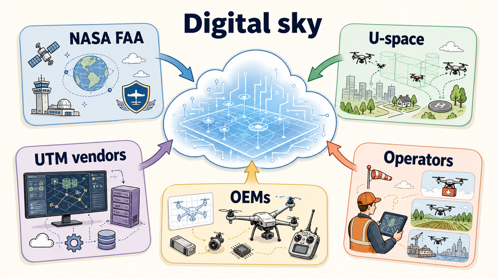
The industry answer is UTM — UAS Traffic Management (also uncrewed traffic management): a highly automated, often federated system for sharing flight intent, airspace constraints, and strategic/tactical deconfliction, especially at low altitude, without putting every vehicle on a controller frequency.
NASA and the FAA co-developed the U.S. conceptual spine: operators and USS (UAS Service Suppliers) exchange digital plans; the air navigation service provider sets constraints; services authorize, track, and alert. ICAO publishes a global UTM framework so states do not invent incompatible islands. Europe names its regulatory ecosystem U-space, with certified USSP (U-space Service Providers) and CISP (Common Information Service Providers) under EU regulations that entered force in 2021 (e.g. Reg. 2021/664 lineage).
Core service ideas (names vary by region):
| Service idea | Job |
|---|---|
| Geo-awareness / constraints | No-fly, TFRs, altitude ceilings as data |
| Flight authorization / planning | Pre-flight strategic deconfliction |
| Tracking / network remote ID cousins | Who is where |
| Traffic information | Nearby cooperative traffic |
| Conformance / alerts | Off-plan warnings |
| Bridge to ATM | Keep manned aviation safe at the seams |
LAANC (Low Altitude Authorization and Notification Capability) in the U.S. is an early, limited cousin—digital authorization near airports—not full city-scale UTM, but proof that API airspace beats faxed waivers.
Part 108 BVLOS normalization (see chapter 10) and UTM are coupled: routine beyond-visual operations without digital traffic services would recreate the intersection problem at industrial scale.
Uber Air / Elevate — the rideshare mind enters the sky
❓ What was Uber Elevate, and what remains after Uber left?
In October 2016, Uber published the Elevate white paper on on-demand urban air transportation—VTOL networks, skyports, rider experience, and the claim that rideshare data could site infrastructure where demand already exists. Annual Elevate summits (roughly 2017–2019) pulled OEMs, cities, and NASA-adjacent thinkers into one circus tent. The vision was multimodal: car to vertiport to eVTOL to car, not a garage Jetsons fantasy.
Uber also ran Uber Copter experiments with conventional helicopters (e.g. NYC) as a demand and UX probe—not pure eVTOL proof.
In 2020, Joby Aviation acquired Uber Elevate (assets/rights/team DNA depending on recounting). The network software and airspace-integration people did not vanish; they migrated into an OEM-centric AAM stack. Joby-side narratives later reference elevate-era software threads (e.g. airspace services talent; product names like ElevateOS appear in secondary writeups). The strategic lesson: the hard product is not only the airframe—it is the network operating system that books, sequences, and deconflicts trips.
Uber did not “finish ATC.” It popularized AAM as a mobility network problem and then sold the ambition to a company that builds vehicles for that network.
Who else is building the digital sky
❓ Which organizations actually ship UTM-like capability?
Public R&D and regulators
- NASA UTM project — field demonstrations, architecture principles, research transition toward FAA
- FAA — UTM concept maturation, LOAs for service suppliers in operational evaluation consortia, LAANC, BVLOS rulemaking interface
- EASA / EU U-space — binding regulatory frame; USSP/CISP certificates
- ICAO — global framework documents for harmonization
- National ANSPs experimenting with U-space airspace designations (e.g. early European city/region designations reported in industry press)
Commercial UTM / digital airspace vendors (illustrative, not exhaustive; market is fluid)
| Party | Role / note (mid-2020s open sources) |
|---|---|
| ANRA Technologies | UTM / U-space platforms; claims of high monthly commercial op counts; FAA LOA narratives; EASA USSP-related positioning |
| Airspace Link | U.S. digital airspace / authorization ecosystem collaborations |
| AirMap (historical leader; industry consolidation eras) | Early UTM brand in many market maps |
| Altitude Angel (GuardianUTM) | Major UK/EU UTM player; administration/insolvency stress reported 2025; Indra acquisition of GuardianUTM assets reported Jan 2026 |
| Indra / Thales / Airbus | Large ATM/ANSP suppliers extending into UTM |
| Droniq and national USSP candidates | Regional U-space service delivery |
| Terra Drone and other global UTM offerings | Operator-facing airspace services |
| AAM OEMs (Joby, Archer, …) | Vehicle + ops software + airport/vertiport integration; not pure ATC replacements |
| Delivery operators (Wing, Zipline, Amazon Prime Air, …) | Private ops stacks that must eventually federate with public UTM/ATM |
Contrarian / market reality: UTM vendors can fail commercially even when the need is real—Altitude Angel’s distress is a Sinatra-test warning that regulation pace and revenue models lag demos. Consolidation into defense/ATM giants may be the durable path.
Corridors, layers, and the return of structure
❓ If 3D frees us, why do people keep drawing sky highways?
Because noise, predictability, emergency response, and detect-and-avoid favor structure. Research and industry concepts often propose:
- Altitude banding (e.g. different bands for small UAS vs air-taxi cruise—exact feet vary by city concept)
- One-way flows in dense corridors
- Climb/descend transition layers near vertiports so arrivals and departures do not share a blender
- Geofenced volumes instead of infinite free flight
This is the honest synthesis: 3D geometry provides degrees of freedom; policy converts some of that freedom back into structured volumes so humans can sleep.
Convergence with the rest of this package
❓ How does ATC/UTM sit on the limiter stack?
UTM is the rules + links + autonomy face of scaling:
- Without it, BVLOS fleets recreate planar conflicts digitally.
- With only private siloed apps, you get walled gardens that collide at the boundary.
- With mature federated UTM + ATM bridges, mass drone logistics and AAM share a sky with manned traffic.
It is strong convergence of networks, AI (for prediction and authorization), sensors (surveillance), and regulation—not a side quest.
Practical takeaway
Cars jam because planar geometry plus shared pavement forces meetings. Drones and flying taxis can miss in height when two paths cross on a map—but only if intent is shared, volumes are reserved, and choke points are managed. Uber Elevate named the network dream; NASA/FAA/EASA named the public architectures; ANRA, Airspace Link, Indra/GuardianUTM heirs, Thales, Airbus, and national USSPs build pieces of the plumbing. The next milestone is not another airframe render. It is boring, certified, overlapping operations—the aerial equivalent of traffic lights that do not need a human on every corner.